Formatting Mapfiles#
With MapServer Studio, you can easily format your Mapfiles. Simply click the “Format” button on the toolbar to automatically format your file. By default, this also checks for any syntax errors in your Mapfile.

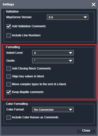
You can customise the formatting options by clicking the “Settings” button and accessing the “Settings” dialog.
Note
You can leave the Settings options screen open and continue to click the Format button to reformat your Mapfile using various options.
Formatting options are detailed below. Formatting is powered using mappyfile - please see the Pretty Printing documentation for further details.
Indent Level#
This setting allows you to indent your Mapfile blocks by either 2 or 4 spaces.
# indentation set to 2
LAYER
  NAME "countries"
  TYPE POLYGON
  ...
  CLASS
    STYLE
      COLOR 60 179 113
      OUTLINECOLOR 255 255 255
      OUTLINEWIDTH 0.1
    END
  END
END

# indentation set to 4
  LAYER
      NAME "countries"
      TYPE POLYGON
      ...
      CLASS
          STYLE
              COLOR 60 179 113
              OUTLINECOLOR 255 255 255
              OUTLINEWIDTH 0.1
          END
      END
  END
Quote#
You can choose to use either single or double quotes for values in your Mapfile. This is a personal preference, as both quote types work the same way.
# double quotes
LAYER
    NAME "countries"
    CONNECTION "/data/naturalearth/fgb"
    DATA "ne_10m_admin_0_countries"
    PROCESSING "CLOSE_CONNECTION=DEFER"
    PROJECTION
        "init=epsg:4326"
    END
    ...

# single quotes
LAYER
    NAME 'countries'
    CONNECTION '/data/naturalearth/fgb'
    DATA 'ne_10m_admin_0_countries'
    PROCESSING 'CLOSE_CONNECTION=DEFER'
    PROJECTION
        'init=epsg:4326'
    END
    ...
Add Closing Block Comments#
This option adds each block’s name as a comment next to its corresponding END keyword. This can be useful when editing large Mapfiles
which can have several END tags grouped together.
LAYER
    NAME "countries"
    TYPE POLYGON
    PROJECTION
        "init=epsg:4326"
    END # PROJECTION
    ...
    CLASS
        STYLE
            COLOR 60 179 113
            OUTLINECOLOR 255 255 255
            OUTLINEWIDTH 0.1
        # note the following END keywords are now annotated
        END # STYLE
    END # CLASS
END # LAYER
Align Key Values in Block#
This option vertically aligns keys and values within each block, improving the readability of your Mapfiles.
LAYER
    # the following values are all aligned vertically
    NAME            "countries"
    TYPE            POLYGON
    STATUS          ON
    CONNECTIONTYPE  OGR
    CONNECTION      "/data/naturalearth/fgb"
    DATA            "ne_10m_admin_0_countries"
    EXTENT          -180.0 -90.0 180.0 90
    PROCESSING      "CLOSE_CONNECTION=DEFER"
    CLASS
        STYLE
            COLOR           60 179 113
            OUTLINECOLOR    255 255 255
            OUTLINEWIDTH    0.1
        END
    END
END
Move Complex Types to the End of a Block#
This option moves any Mapfile objects to the bottom of its parent, leaving simple key value pairs at the top of a block.
LAYER
    # simple key, value pairs are moved to the top of the block
    NAME "cities"
    TYPE POINT
    STATUS ON
    CONNECTIONTYPE OGR
    CONNECTION "/data/naturalearth/fgb"
    DATA "SELECT *, 15-LABELRANK AS POINTSIZE FROM ne_110m_populated_places"
    EXTENT -180.0 -90.0 180.0 90
    # PROJECTION and CLASS have nested properties so are moved to the
    # bottom of the LAYER block
    PROJECTION
        "init=epsg:4326"
    END
    CLASS
        EXPRESSION ( [WORLDCITY] = 1 )
        STYLE
            SYMBOL "circlef"
            COLOR "#6A5ACD"
            SIZE [POINTSIZE]
        END
    END
END
Keep Mapfile Comments#
This option keeps any Mapfile comments when reformatting a Mapfile. By default this option is set to ON
to avoid losing comments when clicking the Format button. Sometimes it is useful to strip all comments from a Mapfile,
for example when deploying to production.
Note
Please note that this feature is experimental, and the position of comments in your Mapfile may change when reformatted. This could result in some comments being lost in certain cases.